|
|
Post by jimbo on Dec 24, 2023 19:28:21 GMT
The print run used to be included in the date and print details in a corner of the map.
|
|
|
|
Post by Chris L on Dec 27, 2023 11:02:09 GMT
It has evolved into a hybrid London public transport services map but without the buses. Or National Rail Services....Which are equally - or for the purposes of this map, more - important as buses What is required is a step back in time. The traditional pocket size Tube map and a fold out London's Railways map should return. The cost of the latter should be shared between TfL and the National Rail operators. |
|
Chris M
Global Moderator
Forum Quizmaster
Always happy to receive quiz ideas and pictures by email or PM
Posts: 19,404
|
Post by Chris M on Mar 1, 2024 2:14:41 GMT
I realised I never got around to doing a detailed list of changes between the October and December digital maps:
Brent Cross West added to map, Cricklewood moves down to accommodate
Kentish Town struck through
Bermondsey gains a blue dagger, the label moves from below-left to below the blob to remain wholly within the zone 2 shading
Edmonton Green loses the double arrow
Catford and St Mary Cray become step-free to platform (previously not step-free)
All Heathrow stations gain a dagger. The Terminal 5 label was previously centred below the connector between XR and LU stations, now centred below the LU station. The Terminal 4 label was previously centred below the LU station, the H of Heathrow is now centred in that spot.
The label for Shenfield moves from being above to above left of the blob.
The watermark on the right of the map is reduced in size by a couple of text sizes to that the two London Overground lines both pass through word boundaries.
Map code moves left to be closer to the date.
The advert below the map (for Santander Cycles) encroaches onto the map frame for the first time, but no changes to any lines or labels are required.
|
|
Chris M
Global Moderator
Forum Quizmaster
Always happy to receive quiz ideas and pictures by email or PM
Posts: 19,404
|
Post by Chris M on Mar 1, 2024 2:16:51 GMT
There is now a February 2024 map online, this is a very minor update so it's not worth starting a new thread to list the changes since December:
The Love the Tube 160th roundel is replaced by the standard Underground one (I suspect this is the entire reason for the new edition).
The watermark on the right of the map moves north east significantly - previously the Goblin passed between "Transport" and "for", "Transport" now beings north-east of the line (the Romford-Upminster line passed between "December" and "2023", it now passes between "London" and "February".
The map code format changes significantly - December: 3149092-A01, February: TfL 0011.02.24 as the new code is longer, the width of the key to symbols box is extended slightly.
The advert for Santander Cycles is replaced by one for the TfL Go app, which does not encroach on the map area.
|
|
trainwizard
100 posts in 367 days on the forum. Close enough.
Posts: 125
|
Post by trainwizard on Mar 1, 2024 8:18:55 GMT
The note for Kentish Town has also been updated from "Closed until summer 2024" to "Closed until late summer 2024".
|
|
|
|
Post by su31 on Mar 15, 2024 23:30:22 GMT
There is now a February 2024 map online, this is a very minor update so it's not worth starting a new thread to list the changes since December: The advert for Santander Cycles is replaced by one for the TfL Go app, which does not encroach on the map area. Apparently due to the forthcoming mayoral election Purdah, TfL are not allowed to advertise Santander Cycles on maps in zones 1 & 2 - hence this slight change. |
|
|
|
Post by brigham on Mar 16, 2024 8:31:25 GMT
It's rather less than apparrent to me. Can someone explain?
|
|
Chris M
Global Moderator
Forum Quizmaster
Always happy to receive quiz ideas and pictures by email or PM
Posts: 19,404
|
Post by Chris M on Mar 16, 2024 11:12:01 GMT
I'm struggling to understand why promoting a different part of the transport network (without highlighting any recent changes, forthcoming improvements, etc) would fall under Purdah rules, but this only applying to zones 1 and 2 is frankly bizarre.
|
|
|
|
Post by spsmiler on Mar 16, 2024 19:59:34 GMT
but this only applying to zones 1 and 2 is frankly bizarre. Maybe because the cycle hire scheme only operates in zones 1 and 2? |
|
Chris M
Global Moderator
Forum Quizmaster
Always happy to receive quiz ideas and pictures by email or PM
Posts: 19,404
|
Post by Chris M on Mar 31, 2024 19:18:19 GMT
Another month, another very small update to the tube map: The only change is to London Overground in the Hackney Downs-Bethnal Green area. Previously the line was shown as a single NE-SW line from just west of where it crossed Shoreditch High Street to just beyond Hackney Downs where is split after a short north-south section, with London Fields and Cambridge Heath having daggers to reflect the service pattern. Now the line continues east-west until after both the crossing and Bethnal Green station before turning NE-SW. The line now splits on this diagonal section, with the left branch turning immediately vertical and containing Cambridge Heath and London Fields. The right branch turns vertical slightly later and proceeds direct to Hackney Downs, which now has blobs on each branch and a longer connection to Hackney Central (which along with Homerton has moved east to accommodate). The labels for all mentioned stations have changed - Bethnal Green, Cambridge Heath and London Fields are now on two lines instead of one, the former also switching from above to below the line. Hackney Downs' label moves the NR symbol from left of Hackney to above it. Hackney Central's label moves from above to below the line while Homerton's does the opposite. 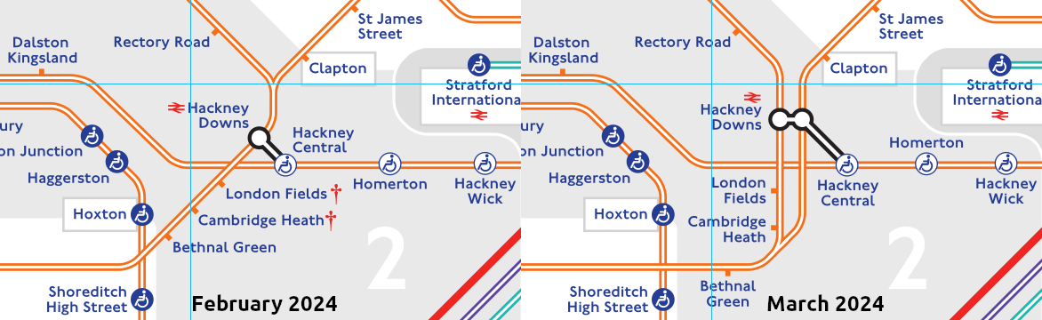 In my opinion this is a positive change as it's much clearer and I'm surprised it wasn't drawn like this from the start. Both the Chingford and Enfield/Cheshunt branches will be part of the Suffragette line post rebrand so it seems unlikely this is the reason it's been changed now. |
|
|
|
Post by f73a on Apr 1, 2024 14:07:32 GMT
Unfortunately, there is still an incorrect URL for Thameslink on the map... should be ".com" rather than ".co.uk"
|
|
|
|
Post by t697 on Apr 1, 2024 15:59:49 GMT
These changes are on what is being called the Weaver lines I think, not Suffragette which is the Goblin.
|
|
|
|
Post by greatkingrat on Apr 1, 2024 22:15:05 GMT
If they feel it is necessary to show that some Overground trains do not stop at Cambridge Heath/London Fields, should the map also show that some Metropolitan line trains do not stop at Northwick Park/Preston Road?
|
|
trainwizard
100 posts in 367 days on the forum. Close enough.
Posts: 125
|
Post by trainwizard on Apr 4, 2024 10:50:36 GMT
This will be a helpful update. I think the TfL Go app has been showing the lines separated like this previously. Also, interestingly, the two Bethnal Greens are now closer and positioned opposite to each other.  If they feel it is necessary to show that some Overground trains do not stop at Cambridge Heath/London Fields, should the map also show that some Metropolitan line trains do not stop at Northwick Park/Preston Road? Maybe, but I think the crucial difference is that not all Uxbridge trains stop at Northwick Park/Preston Road, and not all Moor Park-bound trains skip Northwick Park/Preston Road. |
|
|
|
Post by xtmw on Apr 16, 2024 19:28:18 GMT
Seems someone has done an oopsie on the online map and made the section between Wanstead and Roding Valley blue instead of red !
|
|
Chris M
Global Moderator
Forum Quizmaster
Always happy to receive quiz ideas and pictures by email or PM
Posts: 19,404
|
Post by Chris M on Apr 16, 2024 20:53:33 GMT
There is indeed a version dated April 2024 that is currently online. All the changes I've seen: Streatham, Petts Wood and Plumstead are now step free to platform (previously not step free) Most lines are a slightly different colour, most notably the Hainault loop is now Piccadilly line blue: Bakerloo: ae520e (Unchanged) Central: ee2622 → e12124 Circle: fdd005 → fccc06 District: 098137 → 14773c H&C: f468a1 → f085ad Jubilee: 94989a → 758189 Metropolitan: 960154 → 831551 Northern: 231f20 (Unchanged) Piccadilly: 263d96 (Unchanged) Victoria: 2d9edf → 36a2e1 W&C: 87d6b5 → 73cea7 DLR: 21b5b0 → 24b3a9 Elizabeth: 5c42a3 → 683d01 Overground: f46f1a → ed641a Trams: 6ec72d → 69c22f Cable car: e51535 → e12124 Thameslink: d66faa (Unchanged) District (limited service): 098137 → 14773c 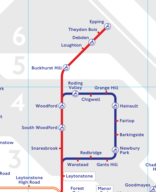 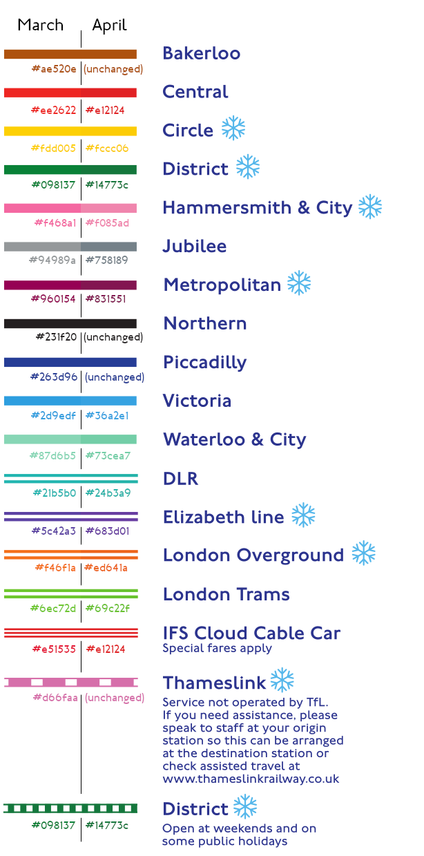 |
|
|
|
Post by jimbo on Apr 17, 2024 0:27:13 GMT
I wonder if the subtle colour changes are in connection with the coming introduction of a range of new Overground colours, now determined?
|
|
|
|
Post by brigham on Apr 17, 2024 7:43:01 GMT
Seems someone has done an oopsie on the online map and made the section between Wanstead and Roding Valley blue instead of red ! Is it the same blue as the Piccadilly, or a subtly different blue? Perhaps the Hainault Loop is shortly to become a 'different mode'. |
|
Chris M
Global Moderator
Forum Quizmaster
Always happy to receive quiz ideas and pictures by email or PM
Posts: 19,404
|
Post by Chris M on Apr 17, 2024 9:24:00 GMT
It's the same blue.
Another version of the map has been released today with no changes since yesterday other than making the loop Central line red.
|
|
|
|
Post by jetblast787 on Apr 17, 2024 10:56:19 GMT
Seems like the map on the TfL site hasn't been updated yet?
|
|
Chris M
Global Moderator
Forum Quizmaster
Always happy to receive quiz ideas and pictures by email or PM
Posts: 19,404
|
Post by Chris M on Apr 17, 2024 14:26:41 GMT
|
|
|
|
Post by d7666 on Apr 18, 2024 14:34:38 GMT
Spin off question; what exactly is the criteria for the "under 10 minute walk between stations" to get on to this map ? It must be more subtle than exactly that.
Taking the example that causes me to ask the question, knowing all the stations, why do New Cross Gate and New Cross get to be linked on the map, but not New Cross linked to Deptford (Thameslink). Look at where else you have to go to rail interchange to get between anywhere south of New Cross Gate to anywhere east of Deptford. Maybe buses are far better, but then is that one of the criteria for exclusion ?
I am sure there are many many other examples, it just happens I know those stations and walks; NX/NXG I agree is a striaght line down one main road while NX/deptford is a zig zag but I reckon they are equal in times, which is what the criteria apears to be.
Not so much asking if anyone actually needs or makes such connections, just what qualifies some to get on the map and not others.
Maybe the subject is ummm err subjective. For example, one I routinely use that is incredibly useful TO ME is Waterloo to Blackfriars on foot. Ok this is probably on the boundary of a 10 min walk, but I can see why this one is NOT on a tube map, as the way I see it it is not likely to be a logical route between the Underground lines at Waterloo and Blackfriars; my use of it is main line Waterloo to Thameslink Blackfriars, which is not really the purpose of the tube map to mark such routes. By the time you have faffed around and got off a main line train and down on to a tube platform, can be well on the way on foot the Blackfriars, and, going to Luton, that means StPancras if going by tube, so is clunky as involves a tube interchange and a long walk in the Kings Cross nexus. The other way to do it is tube to London Bridge, but that can cause a 15 min step back in the TL train I get as you are doing a counter flow to get to it. But that's my personal take on that particular routine journey. Just to add only doing this one since the south bank exit of Blackfriars opened, before that the walk to the north bank over Blackfriars bridge tipped against it espcially when TL was less frequent.
|
|
|
|
Post by spsmiler on Apr 18, 2024 16:23:16 GMT
Seems someone has done an oopsie on the online map and made the section between Wanstead and Roding Valley blue instead of red ! Is it the same blue as the Piccadilly, or a subtly different blue? Perhaps the Hainault Loop is shortly to become a 'different mode'. I suspect that xtmw was correct - the blue was a mistake. now corrected. |
|
|
|
Post by d7666 on Apr 18, 2024 19:41:33 GMT
Is it the same blue as the Piccadilly, or a subtly different blue? Perhaps the Hainault Loop is shortly to become a 'different mode'. I suspect that xtmw was correct - the blue was a mistake. now corrected. Indeed. Is was the blue on the loop the same as the text blue ? In which case I suggest the default base coulor might be blue for everything, then the lines coloured as approprate. That would be a simple way to do it. So rather than it being an active error that the loop was coloured blue by someone, it was a passive error in that altering the loop from base blue to Central red was left out by everyone. |
|
Chris M
Global Moderator
Forum Quizmaster
Always happy to receive quiz ideas and pictures by email or PM
Posts: 19,404
|
Post by Chris M on Apr 18, 2024 20:49:49 GMT
The blue on the loop is/was the same as the text blue, Piccadilly line blue, step-free blue and (going back a bit) TfL Rail blue.
|
|
|
|
Post by brigham on Apr 19, 2024 7:25:19 GMT
While we're on, what happened to the gap at Hainault?
As a kid, I always wanted to go there, to see what it looked like in real life.
|
|
|
|
Post by Dstock7080 on Apr 19, 2024 8:13:52 GMT
Disappeared from Tube maps in November 1992, when through services introduced
|
|
|
|
Post by spsmiler on Apr 19, 2024 10:45:02 GMT
While we're on, what happened to the gap at Hainault? As a kid, I always wanted to go there, to see what it looked like in real life. It was only ever a paper gap - in reality platforms i and 2 are and always were through platforms, even if they were not always used as such. But when London Transport took over this route they rebuilt one of the platforms 2 in to an island and replaced its ornate full-length Great Eastern Railway platform canopy with a half-length Art Deco canopy, and the new platform leads in to the depot at its northern end. |
|
trainwizard
100 posts in 367 days on the forum. Close enough.
Posts: 125
|
Post by trainwizard on Apr 28, 2024 20:01:22 GMT
Most lines are a slightly different colour Are minor colour changes like this usual? Have the colours of lines on the tube map been similarly tweaked before? |
|
|
|
Post by Chris L on Apr 28, 2024 21:01:38 GMT
Most lines are a slightly different colour Are minor colour changes like this usual? Have the colours of lines on the tube map been similarly tweaked before? In my time before the mid 80s the map was printed with individual colours for the lines. We then tried to convert to 4 colour printing to save money. It proved impossible to create the colours from cyan, magenta, yellow and black. The maps were then printed in 6 colours. These changes did produce slight colour differences. |
|