|
|
Post by spsmiler on Apr 12, 2023 11:10:10 GMT
I found this online - I was looking for a map showing distances between stations and also found this fascinating map, which shows distances from Ongar of the entire system - including some 'staff only' sections of line, closed lines, unbuilt extensions (Denham, Watford Market, Camberwell more), the DLR, Tramlink, Overground, Tower Subway and Mail Rail. Tramlink is included as its more of a railway with short trains than a traditional street tramway, but not the Kingsway Subway One gripe. The Metropolitan Ralways unbuilt planned extensions are excluded - relief line to Edgware Road and extension from Stanmore to St Albans. This is a pdf file, nowadays these should open in web browsers www.railwaycodes.org.uk/line/track/distances/undergrounddistances.pdf |
|
Dstock7080
Administrator
Posts: 5,805
Member is Online
|
Post by Dstock7080 on Apr 12, 2023 13:29:42 GMT
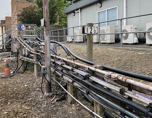
the kilometre post just beyond Upminster shows "12.0":  |
|
|
|
Post by jimbo on Apr 16, 2023 18:26:42 GMT
That's an amazing map. So much content and detail. And a very readable layout.
|
|
|
|
Post by spsmiler on Apr 16, 2023 23:36:00 GMT
the kilometre post just beyond Upminster shows "12.0":  how is that measured? by the railway route via Mile End? |
|
|
|
Post by jimbo on Apr 17, 2023 0:15:42 GMT
|
|
DWS
every second count's
Posts: 2,487
|
Post by DWS on Apr 17, 2023 0:58:17 GMT
the kilometre post just beyond Upminster shows "12.0":  Looks like this on 51rd on the track between Upminster station and Upminster Depot. Has been over 15 years ago since I used this walk way ! |
|


